
Blog Intro
In a world where data is the new oil and real-time visibility is paramount, the ability to know the precise location of assets, people, and equipment is no longer a luxury, it is a strategic necessity. From sprawling global supply chains to the intricate dance of a smart factory floor, and from the controlled environment of a hospital to the vast expanse of an open-pit mine, tracking technologies are the invisible threads weaving our physical and digital worlds together. But the world of location tracking is not a one-size-fits-all landscape. It is a complex and diverse ecosystem of technologies, each with its own unique language of operation, its own set of strengths, and its own inherent limitations.
This comprehensive guide is designed to be your definitive resource for understanding the four most prominent players in the asset tracking arena: the Global Positioning System (GPS), Radio Frequency Identification (RFID), Ultra-Wideband (UWB), and Bluetooth Low Energy (BLE). We will journey deep into the core of each technology, demystifying the science behind how they work, from the satellite constellations of GPS to the backscatter principles of RFID, the high-frequency pulses of UWB, and the ubiquitous connectivity of Bluetooth.
We will move beyond the technical jargon to provide a clear-eyed, practical comparison of their capabilities. Which technology offers centimeter-level precision? Which can operate for years on a single coin-cell battery? Which is best for tracking a global fleet of shipping containers, and which is ideal for ensuring a surgical tool is never left behind? We will explore their respective advantages and disadvantages in terms of accuracy, range, cost, power consumption, and scalability.
Through a detailed survey of real-world applications, we will see these technologies in action, transforming industries and creating new possibilities. We will analyze the market trends shaping the future of asset tracking and provide a clear framework to help you, whether you are an engineer, an operations manager, a business leader, or simply a curious technologist, to select the right tracking technology for your specific needs. Join us as we navigate the exciting and ever-evolving world of location intelligence.
Content
Chapter 1: The Global Standard - Understanding GPS (Global Positioning System)
How GPS Works: A Symphony of Satellites
The Global Positioning System (GPS) is a marvel of modern engineering, a satellite-based radionavigation system owned by the United States government and operated by the United States Space Force. While its origins are military, GPS has become a ubiquitous and indispensable utility for civilian life, quietly powering everything from the navigation app on your smartphone to the complex logistics of global trade.
At its core, GPS works through a simple yet elegant principle: trilateration. The system consists of a constellation of at least 24 operational satellites (and often more, to provide redundancy) orbiting the Earth in a precise and carefully orchestrated pattern. Each satellite continuously broadcasts a signal that contains two key pieces of information: its exact location in space and the precise time the signal was sent, as determined by an incredibly accurate onboard atomic clock.
A GPS receiver on the ground, such as in a vehicle tracker or a smartphone, listens for these signals. When it receives a signal from a satellite, it notes the exact time of arrival. By subtracting the time the signal was sent from the time it was received, the receiver can calculate the distance to that satellite (since the signal travels at the constant speed of light).
However, knowing the distance to a single satellite is not enough. It only tells the receiver that it is located somewhere on the surface of a sphere with the satellite at its center. By receiving a signal from a second satellite, the receiver can narrow its location down to the intersection of two spheres, which is a circle. A third satellite signal narrows the location down to just two points on that circle. Finally, a fourth satellite is needed to resolve which of the two points is the correct one and, crucially, to synchronize the receiver's clock with the highly accurate atomic clocks of the GPS system. This fourth signal corrects for any timing errors in the receiver's less-precise internal clock, which is a critical step for achieving high accuracy.
This process, known as trilateration, happens continuously and in real-time, allowing a GPS receiver to calculate its latitude, longitude, altitude, and velocity with remarkable precision.
GPS: Strengths and Weaknesses
Strengths:
- Global Coverage: The primary advantage of GPS is its near-ubiquitous coverage. With a clear line of sight to the sky, a GPS receiver can determine its location anywhere on Earth, from the middle of the ocean to a remote desert.
- High Accuracy (Outdoors): In ideal conditions, standard GPS provides a location accuracy of within 3 to 10 meters. This is more than sufficient for a vast range of outdoor applications.
- No Infrastructure Required (for the user): The entire infrastructure (the satellites and ground control stations) is maintained by the U.S. government. Users only need a GPS receiver, with no need to install their own anchors or readers.
Weaknesses:
- Poor Indoor Performance: GPS signals are relatively weak (equivalent to the light from a car's taillight as seen from hundreds of miles away) and operate at high frequencies (in the L-band, around 1.2 to 1.6 GHz). These signals are easily blocked by solid structures like buildings, roofs, and even dense foliage. This makes GPS highly unreliable for any indoor tracking application.
- High Power Consumption: GPS receivers need to be actively listening for and processing satellite signals, which consumes a significant amount of power. This makes them less suitable for small, battery-powered tags that need to operate for months or years without a recharge.
- Line-of-Sight Requirement: The receiver must have a relatively unobstructed view of the sky to lock onto the necessary number of satellites. In dense urban canyons or mountainous terrain, signal reception can be compromised.
Use Cases for GPS
Given its strengths and weaknesses, GPS is the undisputed king of outdoor, long-range tracking. Its most common applications include:
- Fleet Management: Tracking the location of trucks, delivery vans, and service vehicles for route optimization, fuel management, and driver safety.
- Logistics and Shipping: Monitoring the location of shipping containers, railcars, and high-value cargo as they move across the globe.
- Agriculture: Guiding autonomous tractors and combines for precision farming, and tracking the location of livestock in large pastures.
- Construction and Heavy Equipment: Tracking the location and utilization of valuable assets like bulldozers, excavators, and cranes on large job sites to prevent theft and optimize usage.
- Personal Vehicle Tracking: For anti-theft and recovery purposes.
Chapter 1.5: GPS Enhancement Technologies and Assisted Systems
While standard GPS provides impressive outdoor accuracy, several enhancement technologies have been developed to push its capabilities even further and to address some of its inherent limitations.
Assisted GPS (A-GPS)
Assisted GPS is a technology that significantly reduces the time it takes for a GPS receiver to get its first position fix (known as Time to First Fix, or TTFF). A cold start on a standard GPS receiver can take 30 seconds to several minutes, as the receiver must download orbital data (almanac and ephemeris) from the satellites. A-GPS uses a cellular or internet connection to download this data from a server, which already has it pre-computed. This allows the receiver to lock onto satellites much faster, often in just a few seconds. A-GPS is the standard technology used in smartphones and is the reason your phone can find your location so quickly.
Differential GPS (DGPS) and Real-Time Kinematic (RTK)
For applications that require accuracy beyond the standard 3-10 meters, such as precision agriculture, surveying, and autonomous vehicle guidance, Differential GPS and RTK systems are used. DGPS uses a network of fixed, ground-based reference stations to broadcast the difference between the positions indicated by the GPS satellite systems and the known fixed positions. This correction data can improve accuracy to within 1-3 meters. RTK takes this a step further by using carrier-phase measurements (rather than just the code-based measurements used by standard GPS) and real-time corrections from a nearby base station. RTK can achieve centimeter-level accuracy, making it suitable for the most demanding positioning applications. However, RTK requires a nearby base station and a continuous data link, which limits its range and adds complexity.
Multi-Constellation GNSS
GPS is actually just one of several Global Navigation Satellite Systems (GNSS). Other systems include Russia's GLONASS, Europe's Galileo, and China's BeiDou. Modern GNSS receivers are designed to receive signals from multiple constellations simultaneously. By having access to a larger pool of satellites, these multi-constellation receivers can achieve a faster time to first fix, better accuracy, and more reliable performance, especially in challenging environments like urban canyons where buildings may block the view of some satellites.
Understanding these enhancement technologies is important because they demonstrate that GPS is not a single, monolithic technology but a family of solutions with varying levels of accuracy and complexity. For most asset tracking applications, standard GPS or A-GPS is sufficient. But for specialized applications that demand higher precision, DGPS and RTK provide powerful, albeit more complex and costly, alternatives.
Chapter 2: The World of Radio Waves - Demystifying RFID (Radio Frequency Identification)
Where GPS provides a solution for the macro, outdoor world, Radio Frequency Identification (RFID) offers a powerful and versatile toolkit for the micro, indoor world. RFID is not a single technology, but a family of technologies that use radio waves to automatically identify and track tags attached to objects. Unlike GPS, which is about finding a location in open space, RFID is primarily about presence, identification, and tracking within a defined area, from a single doorway to an entire warehouse.
How RFID Works: A Conversation Between Tag and Reader
An RFID system, at its simplest, consists of two main components: an RFID tag and an RFID reader.
- The RFID Tag: This is the data carrier. It is a small device consisting of a microchip (which stores the data, typically a unique ID) and an antenna (which transmits and receives the radio signals). Tags can be attached to or embedded in virtually any object.
- The RFID Reader (or Interrogator): This is the data capture device. It is a radio transceiver that emits a radio signal to activate the tag and read the data from it. The reader then passes this data to a backend computer system for processing.
The communication process is analogous to a simple conversation. The reader sends out a radio signal, effectively asking, "Is anyone there?" When a tag enters the reader's RF field, it "hears" this signal. The energy from the reader's signal powers up the tag's chip (in the case of passive tags), and the tag then "answers" by sending its unique ID back to the reader. The reader captures this answer and the process is complete. A key advantage of RFID is that this conversation can happen without a direct line of sight, and a reader can talk to hundreds of tags simultaneously.
The RFID Family: LF, HF, and UHF
RFID technology is not monolithic; it operates across three main frequency bands, each with distinct characteristics that make it suitable for different applications.
-
Low Frequency (LF) RFID:
- Frequency: 125-134 KHz
- Characteristics: LF RFID has a very short read range, typically only a few centimeters. The signals can penetrate materials like water and animal tissue well, but they have a slow data transfer rate.
- Use Cases: Because of its short range and reliability around liquids, LF is ideal for applications like animal identification (e.g., microchips for pets), access control (e.g., office key fobs), and car key immobilizers. The short range is a security feature in these cases, preventing unauthorized reads from a distance.
-
High Frequency (HF) RFID:
- Frequency: 13.56 MHz
- Characteristics: HF RFID offers a slightly longer read range than LF, typically from a few centimeters up to about a meter. It has a moderate data transfer rate. A significant subset of HF RFID is Near Field Communication (NFC), the technology used in contactless payments and smartphone-based interactions.
- Use Cases: HF is widely used for applications like library book tracking, ticketing (e.g., public transit passes), and secure payments (NFC). Its moderate range and established security protocols make it a good fit for these transactional applications.
-
Ultra-High Frequency (UHF) RFID:
- Frequency: 860-960 MHz (the exact frequency varies by region)
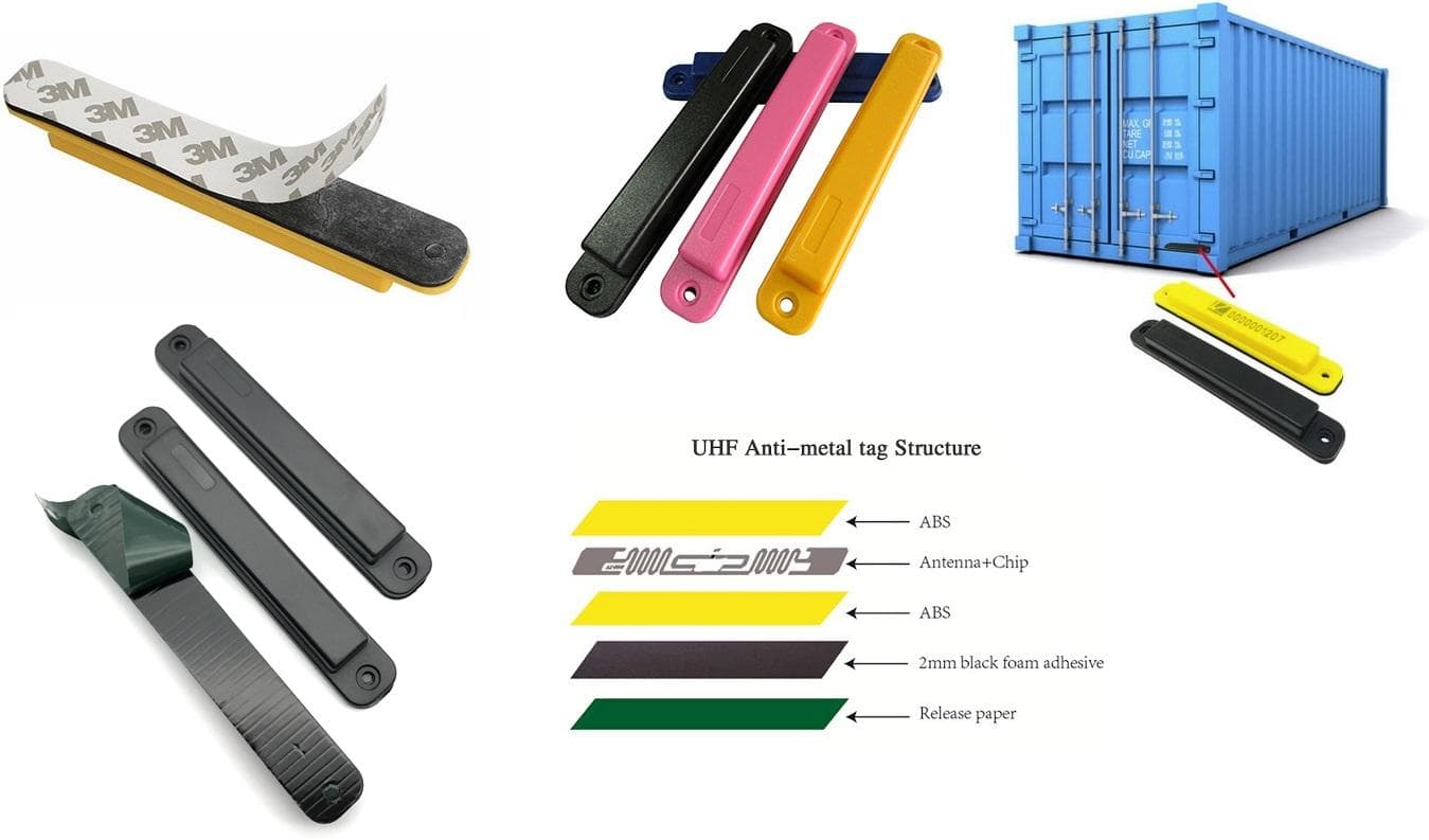
- Characteristics: UHF RFID is the star player for most modern logistics and supply chain applications. It boasts a long read range, from several meters up to 20 meters in ideal conditions, and a very fast data transfer rate. This allows for the rapid scanning of hundreds of tags at once. However, UHF signals are more easily blocked by water and can be susceptible to interference from metal (a problem solved by the anti-metal tags discussed previously).
- Use Cases: This is the technology of choice for warehouse inventory management, retail stock counting, race timing, and tracking assets through a supply chain. Its ability to read many tags quickly from a distance is its key advantage.
Passive vs. Active RFID
Another critical distinction within the RFID world is between passive and active tags.
-
Passive RFID Tags: These are the most common and cost-effective type of tag. They have no internal power source. They rely entirely on the energy from the RFID reader's signal to power their chip and transmit their response. Their range is limited by the amount of power they can harvest from the reader's signal. The vast majority of tags used in inventory and supply chain are passive UHF tags.
-
Active RFID Tags: These tags have their own internal battery. This battery powers the chip and allows the tag to broadcast its own signal at regular intervals. Because they are not dependent on the reader's signal for power, they have a much longer read range (often over 100 meters) and can be used for real-time location systems (RTLS). However, they are significantly more expensive, larger, and have a finite lifespan determined by their battery.
RFID: Strengths and Weaknesses
Strengths:
- No Line-of-Sight Required: Unlike barcodes, RFID tags can be read through packaging, inside containers, and without being directly visible to the reader.
- Bulk Reading: A single RFID reader can identify hundreds of tags simultaneously, dramatically speeding up processes like inventory counting.
- Automation: RFID enables the automation of data capture, reducing manual labor and human error.
- Low Cost (for passive tags): Passive UHF tags are very inexpensive, often costing just a few cents in high volumes, making them viable for tracking individual items.
Weaknesses:
- Limited Precision: Standard RFID is primarily a presence-based technology. It can tell you that an asset is within the read zone of a particular reader (e.g., "in the warehouse" or "passing through dock door 4"), but it does not provide precise X-Y coordinates like UWB or GPS.
- Environmental Interference: The performance of UHF RFID can be affected by materials in the environment, particularly metals and liquids, which can block or reflect the radio waves.
- Infrastructure Cost: While the tags can be cheap, the readers, antennas, and backend software can represent a significant upfront investment.
Use Cases for RFID
RFID's versatility has led to its adoption in a vast array of industries:
- Retail and Apparel: For tracking inventory from the distribution center to the store shelf, enabling accurate stock counts, reducing out-of-stocks, and speeding up checkout.
- Logistics and Supply Chain: For tracking pallets, cases, and individual items as they move through the supply chain, providing real-time visibility and reducing shipping errors.
- Manufacturing: For tracking work-in-process (WIP), managing tools and equipment, and ensuring the correct components are used in assembly.
- Healthcare: For tracking medical equipment, managing pharmaceutical inventory, and ensuring patient safety by matching patients to the correct treatments.
- Access Control: For securing buildings, parking garages, and restricted areas using RFID-enabled ID cards and key fobs.
Chapter 3: The Precision Powerhouse - Unveiling UWB (Ultra-Wideband)
If GPS is the master of the outdoors and RFID is the workhorse of identification, then Ultra-Wideband (UWB) is the surgeon of the tracking world. It is a technology defined by one primary characteristic: extraordinary precision. UWB is a radio technology that, as its name suggests, uses a very wide spectrum of frequency to transmit data. This unique approach allows it to provide real-time location information with centimeter-level accuracy, a capability that sets it apart from almost all other wireless technologies.
How UWB Works: A Matter of Time
Unlike conventional radio systems that transmit data by modulating the power or frequency of a continuous sine wave (like AM or FM radio), UWB works by transmitting a series of very short, low-power pulses of energy across a massive swath of the radio spectrum (typically several gigahertz wide). This is more like sending a rapid burst of digital "blips" rather than a continuous wave.
The key to UWB's precision lies in how it measures location. The most common method is Time of Flight (ToF). The process involves a UWB tag and a set of fixed UWB anchors (transceivers placed at known locations in the environment).
- The tag sends out a wide-spectrum pulse.
- Multiple anchors receive this pulse and time-stamp its arrival with incredible precision (down to the picosecond).
- The tag and anchors can then perform a two-way communication "handshake" to calculate the round-trip time of these pulses.
- By knowing the exact time it took for the pulse to travel from the tag to the anchor and back, and knowing that radio waves travel at the constant speed of light, the system can calculate the precise distance between the tag and each anchor.
Once the system knows the distance from the tag to at least three different anchors, it can use trilateration (the same geometric principle as GPS, but on a much smaller, indoor scale) to pinpoint the tag's exact location in 2D or 3D space with remarkable accuracy.
Another method, Time Difference of Arrival (TDoA), works by measuring the difference in the time that a signal from the tag arrives at multiple anchors. By comparing these time differences, the system can calculate the tag's position relative to the anchors.
UWB: Strengths and Weaknesses
Strengths:
- Unmatched Precision: This is UWB's defining feature. With accuracies of 10 to 30 centimeters, it can provide a level of granularity that other technologies cannot match. This allows for not just knowing that an asset is in a room, but knowing exactly where in the room it is.
- High Reliability and Interference Resistance: Because UWB signals are spread over such a wide frequency band, they appear as very low-level background noise to other radio systems like Wi-Fi and Bluetooth. This makes UWB highly resistant to interference from other wireless devices, a major advantage in crowded RF environments.
- High Data Rate: The wide bandwidth allows UWB to transmit data at very high speeds over short distances, although this is a secondary benefit for most tracking applications.
- Security: The short, pulsed nature of UWB signals makes them more difficult to intercept and jam than traditional radio waves, offering an inherent security advantage.
Weaknesses:
- High Cost: UWB is currently the most expensive of the short-range tracking technologies. The chips are more complex, and the tags and anchors are significantly more expensive than their RFID or BLE counterparts.
- Complex Infrastructure: Implementing a UWB system requires the careful installation and calibration of a network of anchors. The placement of these anchors is critical for achieving high accuracy, and the setup can be complex and time-consuming.
- Shorter Range: While capable of reaching up to 200 meters in ideal line-of-sight conditions, the practical range of UWB for high-precision tracking is typically shorter, often in the 10 to 50-meter range.
- Power Consumption: While more power-efficient than GPS, UWB generally consumes more power than passive RFID or Bluetooth Low Energy, which is a consideration for battery-powered tags.
Use Cases for UWB
The exceptional precision of UWB makes it the ideal choice for applications where knowing the exact location of an asset is critical.
- High-Value Manufacturing: In industries like automotive or aerospace, UWB is used to track the precise location of tools, parts, and vehicles on the assembly line. This can be used to automate processes (e.g., ensuring a robotic arm tightens the correct bolt on a specific component) and to provide a detailed audit trail for quality control.
- Warehouse and Logistics: For tracking the movement of forklifts and other vehicles to optimize routes, prevent collisions, and improve warehouse safety. It can also be used to instantly locate high-value items in a large and cluttered warehouse.
- Worker Safety: In industrial environments like mining or construction, UWB tags can be worn by workers to create virtual safety zones around heavy machinery. If a worker enters a dangerous area, an alarm can be triggered automatically.
- Sports Analytics: UWB tags are placed on athletes and equipment (like a football or a race car) to track their precise movements, speed, and interactions in real-time, providing a wealth of data for performance analysis.
- Secure Access Control: UWB's precision and security are being used to create next-generation keyless entry systems for cars and buildings, where the system knows not just that you are near, but your exact position and orientation relative to the door.
Chapter 4: The Ubiquitous Connector - Leveraging Bluetooth and BLE
Bluetooth is a technology that needs little introduction. It is the invisible force that connects our wireless headphones, speakers, and keyboards to our computers and smartphones. However, the introduction of Bluetooth Low Energy (BLE) in 2011 as part of the Bluetooth 4.0 specification transformed the technology from a simple cable replacement into a powerful and efficient tool for the Internet of Things (IoT) and, specifically, for location tracking.
How BLE Works: Beacons and Signal Strength
While classic Bluetooth was designed for continuous, streaming data (like music), BLE was designed for short, intermittent bursts of information, with a primary focus on minimizing power consumption. This makes it ideal for small, battery-powered devices that need to operate for months or even years on a single coin-cell battery.
Location tracking with BLE is most commonly achieved using beacons. A BLE beacon is a small, simple transmitter. It does not actively track anything itself; its only job is to repeatedly broadcast a signal containing its own unique ID. This is like a tiny lighthouse constantly shouting, "I am Beacon 123, and I am here!"
A receiving device, such as a smartphone or a dedicated BLE gateway, listens for these beacon signals. The primary method for determining location with BLE is by measuring the Received Signal Strength Indicator (RSSI). RSSI is a measurement of how strong the beacon's signal is when it reaches the receiver. The basic principle is simple: the stronger the signal, the closer the receiver is to the beacon.
By placing multiple beacons at known locations, a system can use the RSSI readings from these beacons to estimate the location of a receiving device. For example, if a smartphone sees a strong signal from Beacon A and a weak signal from Beacon B, it can infer that it is much closer to Beacon A. This provides what is known as proximity-based location, or "dot-on-a-map" positioning. It can tell you which room an asset is in, but not its precise coordinates within that room.
More advanced BLE positioning systems use techniques like trilateration (similar to GPS and UWB, but using RSSI to estimate distance) or, with the advent of Bluetooth 5.1, Angle of Arrival (AoA) and Angle of Departure (AoD). The AoA method uses an array of antennas on the receiver to determine the precise angle from which a beacon's signal is arriving. By getting the angle from multiple receivers, the system can triangulate the tag's position with much higher accuracy, often achieving sub-meter precision.
BLE: Strengths and Weaknesses
Strengths:
- Extremely Low Power Consumption: This is BLE's standout feature. Beacons can operate for years on a small battery, making them ideal for "deploy and forget" applications.
- Low Cost: BLE beacons and tags are very inexpensive, making it economically feasible to deploy them in large numbers for tracking many assets.
- Ubiquity: Bluetooth is built into virtually every smartphone, tablet, and laptop on the planet. This means that in many cases, the receiving infrastructure (the smartphones of employees or customers) already exists, which can significantly lower the barrier to entry.
- Ease of Deployment: Setting up a BLE beacon system is often as simple as sticking the beacons to walls or objects and using a smartphone app to configure them.
Weaknesses:
- Variable Accuracy (with RSSI): Location accuracy based on RSSI can be inconsistent. Signal strength can be affected by many environmental factors, such as physical obstacles (walls, people), other radio signals, and even the orientation of the receiving device. This typically limits RSSI-based accuracy to the 1-5 meter range.
- Interference: BLE operates in the crowded 2.4 GHz frequency band, which it shares with Wi-Fi, Zigbee, and microwave ovens. While BLE has built-in mechanisms to hop between frequencies to avoid interference, performance can still be degraded in very congested RF environments.
- Requires Gateways for Real-Time Tracking: While smartphones can be used as receivers, for a true real-time asset tracking system (where you want to see the location of all assets on a central dashboard), a dedicated network of BLE gateways is required. These gateways listen for beacon signals and forward the data to a central server.
Use Cases for BLE
BLE's combination of low power, low cost, and ubiquity makes it a versatile solution for a wide range of applications.
- Indoor Navigation and Wayfinding: In large venues like airports, museums, and hospitals, BLE beacons can be used to provide turn-by-turn navigation on a user's smartphone.
- Proximity Marketing: Retail stores can use beacons to send targeted advertisements or special offers to shoppers' phones when they enter a specific department or dwell in front of a particular product.
- Asset Tracking: For tracking medium-to-low-value assets within a defined area, such as medical equipment in a hospital, tools in a workshop, or pallets in a warehouse. It provides a cost-effective way to ensure assets are where they should be and can be found quickly.
- People Tracking: In corporate offices or at events, BLE-enabled ID badges can be used to track attendance, monitor building occupancy, and assist with emergency evacuations.
- Consumer Item Finders: Products like Tile and Chipolo use BLE to help people find their lost keys, wallets, and bags by leveraging a crowd-sourced network of other users' phones to find items that are out of the owner's personal range.
Chapter 5: The Ultimate Showdown - A Head-to-Head Comparison
Having explored the inner workings, strengths, and weaknesses of GPS, RFID, UWB, and Bluetooth Low Energy, it is time to bring them together for a direct comparison. Choosing the right technology is not about finding the "best" one overall, but about finding the best fit for a specific problem. This chapter will break down the key differences across the most important metrics: accuracy, range, cost, power consumption, and scalability.
Accuracy: From Global to Granular
This is often the most critical factor and where the differences are most stark.
- UWB (Ultra-Wideband): The undisputed champion of precision. With accuracy in the 10 to 30-centimeter range, UWB can provide a true, real-time X-Y-Z coordinate. This is the technology you choose when you need to know not just that a tool is in the room, but which workbench it is on.
- Bluetooth Low Energy (BLE): BLE offers variable accuracy. Using the standard RSSI (signal strength) method, accuracy is typically in the 1 to 5-meter range, which is best described as "room-level" accuracy. However, with the more advanced Angle of Arrival (AoA) method, BLE can achieve sub-meter accuracy, bringing it much closer to UWB performance, though often with more complex infrastructure.
- GPS (Global Positioning System): GPS provides excellent accuracy, typically 3 to 10 meters, but only outdoors. As soon as it moves indoors, its accuracy plummets, or the signal is lost entirely.
- RFID (Radio Frequency Identification): Standard passive RFID is not a precision location technology. It is a presence-based technology. It excels at telling you when a tag has passed a specific point (a "choke point") or is present within a reader's zone (which could be several meters wide). It answers "what" and "where (zone-level)" but not "precisely where."
Range: From Centimeters to Continents
The effective range of each technology dictates the scale of the problems it can solve.
- GPS: Has a virtually unlimited global range. As long as it can see the sky, it can find its position anywhere on the planet.
- Active RFID: Can achieve a very long range, often over 100 meters, as the tags have their own power source to broadcast a strong signal.
- UHF Passive RFID: Offers a good indoor range, typically up to 20 meters in ideal conditions, which is perfect for scanning a room or a portal.
- Bluetooth Low Energy (BLE): Has a moderate range, officially up to 100 meters, but practically in the 10 to 50-meter range for reliable communication in most environments.
- UWB: While capable of long ranges, its high-precision tracking is most effective at a shorter range, typically 10 to 50 meters between tag and anchor.
- HF/LF RFID: These are very short-range technologies, operating from a few centimeters up to a meter.
Cost: A Spectrum of Investment
The cost of a tracking solution has two main components: the cost of the tags and the cost of the infrastructure (readers, anchors, gateways, software).
-
Tags (from lowest to highest cost per tag):
- Passive RFID: The cheapest by far, often just $0.05 to $1.00 per tag.
- BLE: Very affordable, typically $2 to $25 per tag/beacon.
- Active RFID: More expensive due to the battery, around $5 to $20.
- GPS: GPS trackers are complex devices, costing $20 to $200+.
- UWB: The most expensive tags, usually $25 to $75 each.
-
Infrastructure:
- GPS: Requires no user-deployed infrastructure, which is a major cost advantage.
- BLE & RFID: Require a network of readers or gateways. The cost can vary from a few hundred dollars for a single reader to tens of thousands for a full warehouse installation.
- UWB: Has the highest infrastructure cost, as it requires a precisely installed and calibrated network of expensive anchors.
Power Consumption: The Battery Life Battle
For any battery-powered tag, power consumption is a critical concern.
- Passive RFID: The ultimate low-power solution, as it has no battery and an almost unlimited operational life.
- Bluetooth Low Energy (BLE): The champion of powered technologies. BLE devices are designed for ultra-low power consumption, allowing them to run for months or even years on a small coin-cell battery.
- Active RFID & UWB: These consume more power than BLE but are still relatively efficient. Battery life is typically measured in months to a few years, depending on how frequently they transmit.
- GPS: The most power-hungry of the group. A constantly operating GPS tracker will drain a battery in a matter of hours or days, not months. This is why most GPS trackers use motion sensors to only activate when the asset is moving.
Conclusion: Choosing Your Tool
There is no single winner in this comparison. The best technology is the one that best matches the specific requirements of your use case.
- For global, outdoor tracking of high-value assets where precision of a few meters is sufficient, GPS is the only choice.
- For high-volume, low-cost item identification and inventory management within a defined zone, Passive RFID is unbeatable.
- For high-precision, real-time location tracking in a controlled indoor environment where cost is a secondary concern, UWB is the gold standard.
- For flexible, low-cost, and low-power indoor proximity tracking and navigation, BLE offers a versatile and easy-to-deploy solution.
Often, the most powerful solutions come from combining these technologies. A logistics company might use GPS to track a container on a ship, RFID to scan the contents of the container as it is unloaded, and BLE or UWB to track the individual boxes within the warehouse. Understanding the unique strengths of each technology is the first step to building a truly intelligent and connected asset tracking ecosystem.
Chapter 6: The Technologies in Action - A Survey of Real-World Applications
Theory and specifications are essential, but the true value of these technologies is revealed in how they are applied to solve real-world problems. This chapter will explore a series of practical use cases, illustrating how each tracking technology is uniquely suited to different industries and challenges.
Use Case 1: Global Container Shipping
- The Challenge: A global logistics company needs to track thousands of shipping containers as they travel across oceans, through ports, and over land to their final destinations. They need to know where each container is, whether it has been opened, and if it has been subjected to any shocks or temperature deviations.
- The Solution: A Hybrid GPS and Cellular Approach. Each container is fitted with a rugged tracking device.
- GPS is the primary location technology, providing precise latitude and longitude coordinates when the container is in open areas, such as on the deck of a ship or in a rail yard.
- A cellular modem (4G/5G) is used to transmit this location data back to the company's central servers. The device can be programmed to send updates at regular intervals or when specific events occur.
- Sensors for light (to detect when doors are opened), shock, and temperature are integrated into the device. If a container is opened unexpectedly or experiences a significant impact, the device immediately sends an alert.
- A large, rechargeable battery with a solar panel is used to power the device, ensuring it can operate for months at a time without manual intervention.
- Why it Works: GPS provides the necessary global coverage for this application. The hybrid cellular approach ensures that data can be transmitted cost-effectively whenever the container is within range of a cellular network. This solution provides the macro-level visibility needed to manage a global supply chain.
Use Case 2: Retail Inventory Management
- The Challenge: A large apparel retailer wants to achieve near-perfect inventory accuracy across its hundreds of stores. They need to be able to count their entire stock quickly and frequently, reduce out-of-stocks, and easily locate specific items for customers.
- The Solution: UHF Passive RFID.
- A small, disposable passive UHF RFID tag is attached to the price tag of every single item in the store.
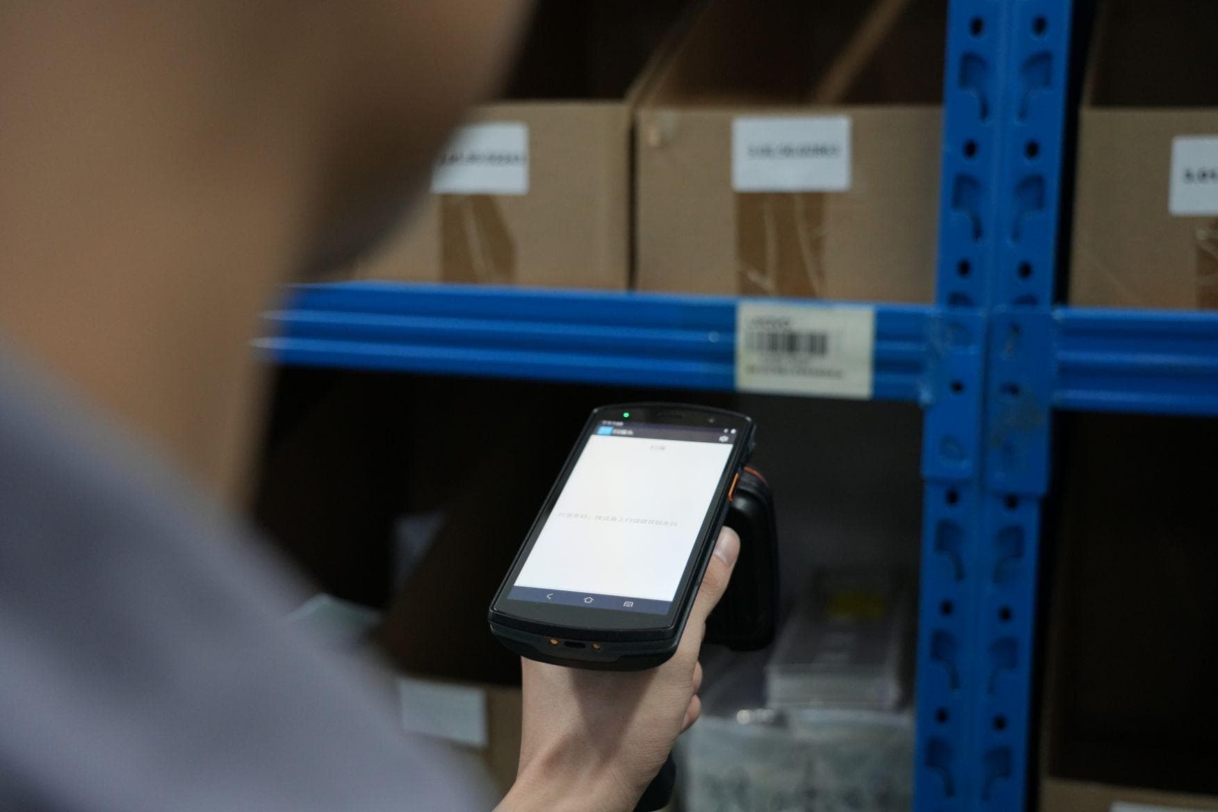
- Store employees use a handheld UHF RFID reader to take inventory. By simply walking down an aisle and waving the reader, they can scan hundreds of items per second, without needing to see or handle each one individually. A full store inventory count can be completed in under an hour, a task that would have taken a team of employees an entire day to do manually with barcodes.
- RFID readers at checkout automatically deactivate the tags of purchased items, and readers at the store exits can be used as an anti-theft system.
- Why it Works: The extremely low cost of passive RFID tags makes it economically feasible to tag every item. The bulk reading capability of UHF RFID is the key to achieving the speed and efficiency required for frequent inventory counts. This is a classic example of using RFID for high-volume, item-level identification.
Use Case 3: Smart Manufacturing and Tool Tracking
- The Challenge: An aerospace manufacturer needs to ensure that the high-torque wrenches used in aircraft assembly are always calibrated correctly and are never left behind inside an aircraft (a critical safety issue known as Foreign Object Debris, or FOD). They also need to track the precise assembly steps for each component.
- The Solution: UWB Real-Time Location System (RTLS).
- A network of UWB anchors is installed throughout the assembly area.
- A small, industrial-grade UWB tag is attached to each torque wrench.
- The system tracks the precise, real-time location of each wrench with centimeter-level accuracy.
- Virtual zones are created in the software. When a wrench is used, the system can verify that the correct tool is being used at the correct workstation and on the correct component. The system can also record the duration of the activity, creating a detailed digital audit trail.
- Before an aircraft panel is closed, a final UWB scan of the area is performed. The system can instantly verify that all tagged tools have been removed from the work area, preventing any possibility of FOD.
- Why it Works: The extreme precision of UWB is the critical enabler here. It is not enough to know that the tool is "in the room"; the system needs to know its exact position to verify the work being done and to ensure safety. The high cost of the system is justified by the immense cost and safety implications of a manufacturing error or a FOD incident.
Use Case 4: Hospital Asset and Patient Flow
- The Challenge: A large hospital wants to improve the utilization of its mobile medical equipment (like infusion pumps and wheelchairs) and reduce the time nurses spend searching for them. They also want to monitor patient flow through the emergency department to identify bottlenecks.
- The Solution: A BLE-based RTLS.
- Small, long-life BLE beacons are attached to each piece of mobile equipment.
- A network of BLE gateways is installed throughout the hospital, plugged into standard power outlets. These gateways listen for the beacon signals and forward the data to the hospital's location server.
- Patients in the emergency department are given a BLE wristband upon admission.
- Nurses can now look at a map on a tablet or computer to see the real-time, room-level location of any piece of equipment they need.
- The system can also provide analytics on asset utilization, showing which departments are hoarding equipment and which assets are underutilized.
- The movement of patients through the emergency department can be tracked, providing data on wait times at each stage (triage, examination, imaging) to help hospital administrators improve processes.
- Why it Works: BLE provides the right balance of performance and cost for this application. Room-level accuracy is sufficient to find a wheelchair or an infusion pump quickly. The low cost of the beacons and the ease of deploying the gateways make it feasible to cover the entire hospital. The very low power consumption means the beacons on the equipment only need their batteries changed every few years, minimizing the maintenance burden.
Chapter 7: The Market Landscape and Future Trends
The world of asset tracking is not static; it is a dynamic and rapidly evolving market, driven by technological innovation, changing business needs, and the overarching trend of digital transformation. Understanding the current market landscape and the future trajectory of these technologies is crucial for making strategic investment decisions. This chapter will analyze the market dynamics for GPS, RFID, UWB, and BLE, and explore the key trends that are shaping the future of location intelligence.
Market Dynamics: A Growing Pie
The overall market for asset tracking is experiencing explosive growth. According to a report by Precedence Research, the global asset tracking market is projected to grow from approximately $26 billion in 2025 to over $106 billion by 2035, registering a compound annual growth rate (CAGR) of over 13%. This growth is fueled by several factors:
- The Rise of the IoT: The proliferation of connected devices and the demand for data-driven insights are pushing companies to gain real-time visibility into their physical operations.
- Supply Chain Complexity: Modern supply chains are more global and complex than ever before. The need to track goods in real-time to improve efficiency, reduce theft, and respond to disruptions is a major driver for tracking technology adoption.
- Increased Automation: In manufacturing, logistics, and even retail, automation is key to improving productivity and reducing costs. Tracking technologies provide the real-time location data that is essential for robotic systems and automated workflows.
- Focus on Safety and Security: In industries like construction, mining, and healthcare, tracking the location of workers and equipment is critical for ensuring safety and security.
While the overall market is growing, each technology has its own specific market dynamics and growth trajectory.
- GPS: As a mature technology, the GPS market is characterized by steady growth and intense competition. The key growth area is in the integration of GPS with other technologies, such as cellular and LoRaWAN, to create more robust and power-efficient solutions for logistics and fleet management.
- RFID: The RFID market, particularly for passive UHF tags, continues to see massive growth, driven by its adoption in retail and logistics for item-level tracking. The cost of tags continues to fall, making it an increasingly attractive solution for high-volume applications.
- UWB: The UWB market is poised for the most dramatic growth. While it currently represents a smaller portion of the market due to its high cost, its unmatched precision is opening up new applications in smart manufacturing (Industry 4.0), automotive, and consumer electronics. The integration of UWB into high-end smartphones (like Apple's U1 chip) is a major catalyst, as it will drive down chip costs and create a broader ecosystem of UWB-enabled devices.
- BLE: The BLE market is also experiencing rapid growth, fueled by its low cost, low power consumption, and ubiquity in smartphones. It is becoming the de facto standard for indoor positioning, proximity marketing, and connected devices in the smart home and healthcare sectors.
Future Trend 1: The Convergence of Technologies (Hybridization)
The future of asset tracking does not belong to a single technology. It belongs to the intelligent combination of multiple technologies to create hybrid solutions that are greater than the sum of their parts. We are already seeing this trend accelerate:
- Indoor/Outdoor Tracking: Devices are emerging that seamlessly switch between GPS for outdoor tracking and BLE or Wi-Fi for indoor positioning. A package can be tracked via GPS on a truck, and then its location can be refined using BLE once it enters the warehouse, providing end-to-end visibility.
- BLE and RFID: Combining the long-range, always-on nature of active BLE with the fast, bulk-reading capabilities of passive RFID. For example, a pallet could have a BLE beacon for general location tracking within a warehouse, and each box on the pallet could have an RFID tag for rapid scanning at a dock door.
- UWB and BLE: Using BLE for general proximity detection to wake up a UWB radio only when high-precision ranging is needed. This conserves the battery life of the UWB tag while still providing on-demand, centimeter-level accuracy.
Future Trend 2: The Rise of Sensor Fusion
The next generation of tracking tags will not just report their location; they will report their condition. We are seeing a rapid integration of various sensors into tracking tags:
- Temperature and Humidity Sensors: For monitoring the condition of sensitive goods in the cold chain, such as pharmaceuticals and fresh food.
- Accelerometers and Gyroscopes: For detecting shock and impact (e.g., if a fragile package has been dropped), monitoring the orientation of an asset, or detecting motion to conserve battery life.
- Light Sensors: For detecting when a container or package has been opened.
This fusion of location data with environmental data will provide a much richer and more actionable set of insights, enabling true condition monitoring in addition to simple location tracking.
Future Trend 3: AI and Machine Learning at the Edge and in the Cloud
The sheer volume of data generated by a large-scale tracking deployment can be overwhelming. Artificial Intelligence (AI) and Machine Learning (ML) will be critical for turning this data into wisdom.
- At the Edge: Intelligent gateways and readers will use ML models to filter and process data locally. For example, a gateway could learn the normal movement patterns in a warehouse and only send an alert when an anomaly is detected, reducing the amount of data that needs to be sent to the cloud.
- In the Cloud: Cloud-based AI platforms will analyze historical location and sensor data to identify patterns, predict future events, and optimize processes. This could include predicting equipment failures based on vibration data, optimizing warehouse layouts based on forklift traffic patterns, or forecasting demand based on the real-time flow of goods.
Future Trend 4: Increased Standardization and Interoperability
As these technologies mature, we will see a greater push for standardization to ensure that devices from different manufacturers can work together seamlessly. Standards like the omlox standard for UWB-based RTLS are emerging to create a common framework for location data, allowing companies to integrate different tracking technologies into a single, unified platform. This will reduce vendor lock-in and make it easier to build large-scale, interoperable tracking solutions.
The future of asset tracking is intelligent, interconnected, and context-aware. It is a future where the physical world is fully represented in the digital realm, not just as a static map, but as a living, breathing, and predictable ecosystem.
Chapter 8: A Practical Decision Framework - How to Select the Right Technology
With so many options available, selecting the right tracking technology can feel overwhelming. This chapter provides a structured, practical framework that any organization can use to evaluate and select the best technology, or combination of technologies, for their specific needs. The decision should not be driven by hype or by the latest buzzword, but by a careful analysis of the actual requirements of the use case.
Step 1: Define Your Environment
The first and most fundamental question is: where do you need to track your assets?
If your assets are primarily outdoors and mobile over long distances, such as vehicles, shipping containers, or heavy equipment on large construction sites, then GPS is the foundational technology. No other technology can provide the global, outdoor coverage that GPS offers. The key sub-question here is about connectivity: how will the GPS data be transmitted back to your servers? Options include cellular (for areas with good coverage), satellite (for remote areas like oceans or deserts), and LoRaWAN (for a cost-effective, long-range, low-power alternative).
If your assets are primarily indoors, such as equipment in a hospital, inventory in a warehouse, or tools in a factory, then GPS is off the table, and you are choosing between RFID, BLE, and UWB. The next steps will help you narrow down the choice.
If your assets move both indoors and outdoors, you will likely need a hybrid solution that combines GPS for the outdoor leg of the journey with an indoor technology for the indoor leg.
Step 2: Determine Your Required Accuracy
Once you know the environment, the next question is: how precisely do you need to know the location?
If you need centimeter-level precision (e.g., for robotic guidance, precise tool tracking, or safety-critical geofencing), then UWB is the clear choice. No other indoor technology can reliably deliver this level of accuracy.
If you need room-level or zone-level accuracy (e.g., knowing which room a piece of equipment is in, or which zone of a warehouse a pallet is located in), then BLE is an excellent and cost-effective choice. With the more advanced AoA technology, BLE can even achieve sub-meter accuracy, which is sufficient for most indoor tracking applications.
If you primarily need presence-based identification (e.g., confirming that an item has passed through a specific point, or counting all items in a specific area), then Passive RFID is the most efficient and cost-effective solution. It is not about continuous location tracking; it is about fast, reliable identification at specific checkpoints.
Step 3: Evaluate Scale and Cost
How many assets do you need to track, and what is your budget?
If you are tracking millions of low-value items (like individual retail products or pharmaceutical packages), the per-unit cost of the tag is the dominant factor. Passive RFID tags, at just a few cents each, are the only economically viable option at this scale.
If you are tracking thousands of medium-value assets (like medical equipment, tools, or pallets), BLE offers a strong balance of cost and capability. The tags are affordable, and the gateway infrastructure is relatively inexpensive.
If you are tracking hundreds of high-value assets in a controlled area (like specialized tools in an aerospace factory or autonomous vehicles in a warehouse), the higher cost of UWB can be justified by the value of the precision it provides and the cost savings it enables through process optimization and safety improvements.
If you are tracking a fleet of vehicles or mobile containers, the per-unit cost of a GPS tracker is higher, but the value of global visibility into these high-value, mobile assets more than justifies the investment.
Step 4: Consider Power and Maintenance
What is the acceptable maintenance burden for your tracking system?
If you want a truly maintenance-free tag, Passive RFID is the answer. With no battery, the tag will last as long as the physical label it is printed on.
If you can tolerate infrequent battery changes (every 1-5 years), BLE is an excellent choice. Its ultra-low power consumption means that battery changes are a rare event.
If you are willing to manage more frequent battery changes or recharging (every few months to a year), UWB and Active RFID are viable. This is often acceptable for high-value assets where the tracking system provides significant operational benefits.
GPS trackers typically require the most power management. They often need to be connected to the vehicle's power supply or use large, rechargeable batteries, sometimes supplemented by solar panels.
Step 5: Think About Integration and Future-Proofing
Finally, consider how the tracking system will integrate with your existing IT infrastructure and how it will scale in the future.
Does the technology support open standards? Can the data be easily integrated into your existing ERP, WMS, or CMMS systems? Does the vendor offer a robust API? Is the technology ecosystem growing, or is it a niche solution with limited vendor support?
By working through these five steps, you can systematically narrow down the options and arrive at a technology choice, or a combination of choices, that is grounded in your actual business requirements, not in marketing hype.
Chapter 9: Common Misconceptions and Frequently Asked Questions
The world of tracking technologies is rife with misunderstandings. This chapter aims to clear up some of the most common misconceptions and answer the questions that are most frequently asked by people who are new to this space.
Misconception 1: GPS Works Everywhere
This is perhaps the most common misconception. Because GPS is so deeply embedded in our daily lives through our smartphones, many people assume it works seamlessly everywhere, including indoors. The reality is that GPS signals are very weak and are easily blocked by solid structures. A standard GPS receiver will not function reliably inside a building, a tunnel, or even under dense tree cover. If you need indoor tracking, you need a different technology. Your smartphone appears to work indoors because it uses a combination of Wi-Fi and cellular tower triangulation (known as Assisted GPS or A-GPS) to estimate your location, not pure GPS. This is a fundamentally different and less accurate method.
Misconception 2: RFID is the Same as a Barcode
While both RFID and barcodes are used for identification, they are fundamentally different technologies. A barcode requires a direct line of sight from the scanner to the barcode label, and it can only read one barcode at a time. An RFID reader can read tags through packaging, around corners, and without a direct line of sight. Crucially, an RFID reader can read hundreds of tags simultaneously. This bulk-reading capability is what makes RFID transformative for applications like inventory counting, where it can be 20 to 30 times faster than barcode scanning.
Misconception 3: UWB is Too Expensive for My Business
While UWB has historically been the most expensive option, costs are falling rapidly. The integration of UWB chips into consumer smartphones (like Apple's U1 and U2 chips, and Samsung's equivalent) is driving massive economies of scale in chip production. Furthermore, the cost of a UWB system should be evaluated not just in terms of the hardware price, but in terms of the Return on Investment (ROI). In many industrial applications, the precision of UWB can prevent a single costly incident (like a safety violation, a lost tool in an aircraft, or a collision between a forklift and a worker) that would far exceed the cost of the entire tracking system.
Misconception 4: Bluetooth is Just for Headphones
Classic Bluetooth and Bluetooth Low Energy (BLE) are quite different in their design and purpose. Classic Bluetooth was designed for continuous, high-bandwidth streaming (like audio). BLE was designed from the ground up for low-power, intermittent data transmission, making it ideal for IoT sensors and tracking beacons. The BLE ecosystem is vast and growing, with billions of BLE-enabled devices shipped every year. It is a serious, enterprise-grade technology for indoor positioning and asset tracking, not just a consumer convenience.
Misconception 5: One Technology Can Do It All
No single tracking technology is a silver bullet. As we have discussed extensively, each technology has its own strengths and weaknesses. The most robust and effective tracking solutions are almost always hybrid systems that combine two or more technologies. Trying to force a single technology to do everything will inevitably lead to compromises in performance, cost, or both. The key is to understand the unique strengths of each technology and to deploy them where they are most effective.
FAQ 1: Can RFID tags be read through metal and water?
It depends on the frequency. Standard UHF RFID signals are significantly affected by both metal and water. Metal surfaces can reflect the signals, causing interference and detuning the tag's antenna. Water absorbs UHF radio energy, reducing read range. However, specialized anti-metal RFID tags have been designed with materials like ferrite absorbers that isolate the tag's antenna from the metal surface, allowing reliable reads even when mounted directly on metal. For applications involving liquids, LF RFID is often a better choice, as its lower frequency signals penetrate water more effectively.
FAQ 2: What is the difference between RTLS and RFID?
RTLS (Real-Time Location System) is a concept, not a specific technology. It refers to any system that can automatically identify and track the location of objects or people in real time. RFID, UWB, BLE, and Wi-Fi can all be used as the underlying technology for an RTLS. So, RFID can be a component of an RTLS, but RTLS is a broader term that encompasses many different technologies. When people talk about RTLS, they are usually referring to systems that provide continuous, real-time location updates, which is more commonly associated with active technologies like UWB and BLE rather than passive RFID.
FAQ 3: How does Bluetooth 5.1 AoA improve tracking accuracy?
Bluetooth 5.1 introduced a feature called Direction Finding, which enables two methods for determining the direction of a signal: Angle of Arrival (AoA) and Angle of Departure (AoD). In AoA, the receiving device (a locator) uses an array of multiple antennas. When a signal from a BLE tag arrives, the phase difference of the signal across the antenna array is measured. From this phase difference, the system can calculate the precise angle from which the signal arrived. By getting the angle from at least two locators at known positions, the system can use triangulation to pinpoint the tag's location with sub-meter accuracy. This is a significant improvement over the traditional RSSI method, which only estimates distance based on signal strength and is much more susceptible to environmental interference.
FAQ 4: Is UWB safe? Does it interfere with other devices?
Yes, UWB is considered very safe. Because UWB signals are spread over a very wide frequency band, the power spectral density (the amount of power at any given frequency) is extremely low. In fact, UWB signals are typically below the noise floor of most other radio systems. This means that UWB devices do not cause meaningful interference with other wireless technologies like Wi-Fi, Bluetooth, or cellular. Regulatory bodies like the FCC in the United States and ETSI in Europe have approved UWB for commercial use, with strict power limits to ensure it coexists safely with other radio services.
FAQ 5: Can I use my smartphone as an RFID reader?
Most smartphones have NFC (Near Field Communication) capabilities, which is a subset of HF RFID. This allows your phone to read HF RFID tags (like those used in contactless payment cards or transit passes) at very close range (a few centimeters). However, smartphones cannot read UHF RFID tags, which are the type used for long-range inventory and logistics tracking. Reading UHF tags requires a dedicated UHF RFID reader, which operates at a different frequency and power level than what is built into a standard smartphone. There are, however, UHF RFID reader accessories (sleds) that can be attached to a smartphone to give it UHF reading capability.
Chapter 10: Conclusion - Choosing the Right Language for Location
We have journeyed through the distinct and diverse worlds of four leading tracking technologies. We have seen that GPS speaks the language of the globe, its voice a constant whisper from the satellites above, offering unparalleled reach for our most wide-ranging assets. We have learned that RFID speaks the language of the masses, its ability to identify hundreds of items in the blink of an eye making it the engine of modern logistics and retail. We have discovered that UWB speaks the language of precision, its meticulous, pulse-based dialect allowing for a level of accuracy that is transforming the factory floor and the world of secure interactions. And we have understood that BLE speaks the language of ubiquity and efficiency, its low-power, low-cost nature making it the quiet connector for the billions of devices that populate our indoor spaces.
There is no single, universal language of location. The idea of a single "best" tracking technology is a fallacy. The true challenge, and the greatest opportunity, lies in becoming multilingual, in understanding the unique grammar and vocabulary of each technology. The most effective solutions are rarely born from a single technology, but from the thoughtful and creative combination of several. A truly smart asset tracking strategy is a hybrid one, leveraging the global reach of GPS, the bulk-scanning efficiency of RFID, the surgical precision of UWB, and the low-power ubiquity of BLE in a single, cohesive system.
The future of location intelligence is not just about knowing where something is; it is about understanding its context, its condition, and its journey. It is about fusing location data with sensor data, and then applying the power of artificial intelligence to transform that raw information into predictive, actionable insights. The technologies we have discussed are the foundational building blocks of this future. By understanding their core principles, their strengths, and their limitations, we can begin to build the truly connected, visible, and intelligent world of tomorrow.
References
[1] atlasRFIDstore. (2024, November 4). RFID vs. UWB Technology - Pros, Cons, and When to Use Which Technology. Retrieved from https://www.atlasrfidstore.com/rfid-insider/rfid-vs-uwb-technology-pros-cons/ [2] CDEBYTE. (2024, August 20). Comparison of BLE vs RFID vs UWB. Retrieved from https://www.cdebyte.com/news/751 [3] Seeed Studio. (2025, November 13). BLE vs UWB vs GPS vs WiFi: Which is the Best Indoor Positioning Technology for Personal Safety?. Retrieved from https://www.seeedstudio.com/blog/2025/11/13/ble-vs-uwb-vs-gps-vs-wifi-which-is-the-best-indoor-positioning-technology-for-personal-safety/ [4] MOKOSmart. (2025, April 15). 10 Types of Asset Tracking Technologies: 2026 Complete Guide. Retrieved from https://www.mokosmart.com/asset-tracking-technologies/ [5] Geoforce. (2023, August 21). The Difference Between GPS, AirTag, and RFID and Which Would be Best for You. Retrieved from https://www.geoforce.com/difference-between-gps-airtag-rfidu/ [6] Precedence Research. (n.d.). Asset Tracking Market. Retrieved from https://www.precedenceresearch.com/asset-tracking-market
Was this article helpful?
Related Articles
Maximizing Asset Visibility: The Ultimate Guide to Anti-Metal UHF RFID Tags
Mar 2, 2026
Mastering UHF RFID in Odoo: Hardware, Workflows, and Best Practices
Mar 2, 2026
Chainway C72 Comprehensive Review: Specs, Pricing, and Top Alternatives
Mar 2, 2026

The Ultimate UWB Module Comparison: Prices, Specs, and Use Cases
Feb 23, 2026